By Verner Läxstrom, 1947.
Translated from “Den Österbottniska Byn” by June Pelo in 1985.
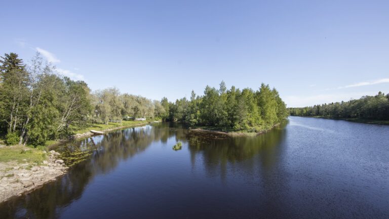
After leaving Gamlakarleby on Uleåborg Road and turning left, one comes on an idyllic village road winding through the cultivated countryside toward the coast. Four kilometers along the road is a bridge which leads over the Gamlakarleby River and Rödsö village is on the other side, the northernmost of the fourteen villages of Karleby parish.
The name was previously written Röttsö and in daily speech read as Röse. The village lies on an island, properly two islands. The islets in the river’s delta land have grown over a period because of the rising shoreline. During the time of the first settlement, the territory was divided into several islands. In older documents one sees the names Laxore, Langore and Littslö. Today the settlements are distributed on two islands, namely the main island and Langorn.
Gamlakarleby River has wandered in the past. The original branch is thought to have gone from the main road bridge northwest to Lidsle farm through the marsh that now lies in the middle of the village, out to the open sea by Haras cove. Later the mainstream headed north through Lidsle and Laxore bays either past the present Sund and Bredskär farms or still farther north through Storlang Sound out to the sea. The south branch originally went in a wide curve to the southwest and south around Vittsar village and received the flow from the swampy ground between Vittsar and Kåustar villages. The stream straightens out farther on and then through a dam, cutting off the south branch so that during spring a great mass of water flows through.
During earlier times the village farmers administered the meadows and woodlands outside the village borders. The meadow lands are situated within Karleby parish, but supplementary wood is found in Halso.
Buildings are concentrated in the middle of the main island and the eastern part around the marsh, also along the river and the bay shore. Only two farms, Sund and Bredskär, belong to the smaller northern island. Around the marsh the ground rises to a low hillside which is very stony. On the north side of the marsh the bedrock juts out to form the Västerberget. A low hill is also found in another place in the village. The village boys use Lidsle and Storsjöbergen as skiing hills. Along the river and bay shore and the valley the ground is very fertile.
The main part of the village territory is small, hilly, and stony. Potato fields have required industrious work. Countless piles of stones which border the road give witness to the work of past generations. To the west, facing the sea, are well wooded hills. Along the coast are separate islets and during western and northwest storms the waves wash up in high cascades on the rocky and stony shore. The population is about 170 to 180 people.
Rödsö village comprises the following number of homesteads which form separate groups of farms:
- Harmas (Härmälä)
- Kankos (Kankkonen)
- Silakka
- Lidsle and Söderback
- Haras (Harald)
- Väster
- Bredskär (3 5/12 mantal)
Along the village embankment are found the following fishing cottages:
- at Storlangoresundet – Hansas, inhabited by families of Björnvik and Borg
- between Laxåback and Harmas in the woods around 300 meters from the road – Björnes, inhabited by the family of Karl Vesterlund; at Harmasbacken – Lindboms, Haralds, Majanders and Lisas
- at Väster – Gretas
- between Haras and Kankos – widow Silanders
- at Lidsle – Hagagubbens and Lena-Majas
- at Söderback – Karl Söderstroms
- along the island shore from the bridge to the sea – merchant Viklunds villa, Karl Hilles and Orres (Karl Silander, Karl Harald, and Fredrik Kankkonen)
- also, along the sea close to the islands – Anton Silanders.
Farm Group No. l:
In the center of the village on the most dominant place lies Harmas farm. The official name Härmälä is not used in the spoken language, but Harmas is the usual form. In older documents a form of the name as Hermans and Hermela is found.
Härmälä is divided into four parts.Two farms are on Harmasbacken. The third is in the same cultivation with Bredskär and the fourth, Laxåback, is situated by the bay shore a kilometer north from Harmas. Both the stately farmhouses on Harmas stand in the north-south direction. Trees and plants are missing because the ground nearest the cottages is of gravel. The farmhouses are referred to in daily speech by the Christian name of the owner, while the back cottages are usually referred to by the owner’s surname. Harmas farm group consists of Alfreds and Mattas and back cottages of Lindboms, Haralds, Majanders and Lisas.
In 1775 Laxåback was separated from Harmas which lies by the bay with the same name. In documents from that time, it was called Laxorebacka. Originally it was a fishing village a couple hundred meters to the east from the present residences on the bay shore. The farms have most of the acreage, meadows, and woodland in a square around the farm. From the farm ground one has an extensive view over the ample bay. Between the buildings and the road stands some aged mountain ash and a birch with bushy crown.
The bay shore meets the sloping green farmland of the dwellings and on the west side is a building consisting of cart shed, stable and fodder barn. The remaining buildings are uphill at an angle to the shed beside the road leading to Sund and Bredskär. The dreamy stillness and solitary surroundings make a strong impression on the visitor.
Farm Group No. 2:
The four Kankos farms belong to this group. They lie two and two and comprise the territory from the island in the south to the marsh in the north on each side of the road that leads through the village. Kalles and Jannes lie on the south side toward the island, and Eiros and Mastäres-Jannes on the north side toward the marsh. When one wanders from the island bridge along a walkway there is a view between the bushy crown of the birches of the farm buildings of the two first named farms, with a long building toward the south. The road goes across the farmyard beside the stairs to Kalles and through an open gate in the long building. The cow houses are uphill beside the road directly after it passes through the gate. During the time of rain, water flows from the roof down on the road, leaving a dirty clay mixture. As a contrast, picture the green idyllic courtyard, the neat farm buildings with plantings on the south and the desired view over the fields, the beautiful birch avenue and in the background the islands and glittering waves – a mood charged with beauty.
Eiros and Mastäres-Jannes lie apart from the above mentioned farms. Mastäres lies on the slope near the marsh on the south side, and Eiros higher up the hill nearest the above mentioned farms close to the road that leads east to Söderback and Lidsle. The outbuildings are placed away so they have a sunny location. Earlier the village road went before both farms down to the marsh shore. The way to Haras goes to the west along the marsh shore and the road to the dwellings on the north side of the marsh and the road used to go east from Eiros to the east shore of the marsh where the wide Donabacka branched out with the easterly branch at Lidsle and then westerly around the marsh, following the northeasterly edge to the dwellings north of the marsh. The present main road through the village goes from the above mentioned Kankos farms along an earlier old road to the west and down to the middle of the marsh where the road goes over a dam to the north shore of Väster farms.
Farm Group No. 3:
There are three Silakka farms, two of them lie east of Harmas hill. Their land stretches from the village road in the south to Lidsle and Laxåback bay in the north. The third farm is Sund which lies on the southeast shore of Langore. The land forms a square around the farm. This farm lies as a passage along from the other so one has difficulty distinguishing one from the other. But when looking at a map, one can see they belong together for their meadows and woodland lie side by side. It is obvious that the three homesteads originally were one, then later divided into three parts. The original that is now called Gammel farm lies on a plain east of Harmas hill about two meters from the village road. Silakka-Nygård lies close to the village road on the eastern slope of Harmas hill. Below them beyond the outbuildings and dwellings is an older cottage built at an angle. The stable and animal building, also fodder barn and woodshed are built around a backyard where the grain is gathered on summer evenings before milking time.
On the steep shore beside the bridge that leads from the main island to Langore lies Sund farm. The dwelling stands with the gable toward the stream where in the spring the breaking ice froths the water from Laxåback bay down toward Gras Bay and past Bredskär to the sea. On the bare hill, where not a tree is found to shelter from sun and wind, stands a beautiful loft with the long side toward the road and at an angle to the dwelling – nowadays it is the only one in the village. In the lower floor of this building is the stable, fodder barn and shop and on the upper floor two rooms. The outbuildings are on other side of the road.
Farm Group No. 4:
Lidsle and Söderback comprise the village’s eastern part. They form the number of homesteads under the official name of Lidsle. Lidsle farms lie on the northeast side of the island at Lidsle bay. Of the four homesteads, only two are separate – Hermans and Lill-Jannes, and the other two are in the same cultivation with Söderback farms. The cultivated land lies around the farms. The buildings are uphill around the square courtyard open to the north. About 500 meters from the farms to the west higher than the ground through the trees is found Lidsleberget. The hill is an immensely good ski hill. From this highest node, one can take a run and steer the skis between trees and through the thicket down to the level – a real man’s test.
The two Söderback farms comprise the southeast part of Lidsle. They have a splendid position on the riverbank with a wide stretch of fertile acreage and cultivated meadow-land. The farm buildings are placed opposite each other and close beside the long outbuildings with square courtyard open to the south. About a kilometer from both dwellings toward the east a wide shore separates a parcel where a brother to one of the Söderback farmers has placed his residence.
Farm Group No. 5:
Haras farms lie southwest of the marsh by the little brook that runs from the marsh to the west out to the island mouth. The three farms are placed in succession along the shore of the brook. The first two, Sovelius and Thylins, with the long side and Anders with the gable toward the brook. On the land between the brook and buildings are planted trees and bushes, so that during the summer the farms are embedded in a luxuriant green. The outbuildings stand in a long row on the other side of the road, so that a shapely village street is formed. The original dwelling had been placed higher up the hillside where one can see the obvious remainder of foundation stones of the building. Haras hill is beside the connection that earlier joined the marsh in the middle of the village with Haras bay.
Farm Group No. 6:
Väster farms comprise the territory on the north marshy shore south of Harmasbacken. The farms are found close to the upper marsh leading the village road on the eastern slope of Väster hill. New Väster lies a half kilometer to the east with Donabacka at the north part of the old village road. At the beginning of the century there were two buildings to the west that divided the land and the dwellings. Blacksmith Matts Väster lived in the north end and his brother Karl Väster in the south. The outbuildings are by the side of the village road. On the other side of the road was where the smith worked. There Matts Väster liked it best. He was least a farmer, mostly smith and designer, and for household purposes he was a miller. It was a delight to see the old man with the forge, the anvil, or file bench. Grimy and black as a Moor he was, but quick, eager, and talkative. On the highest crown of the hill stood the windmill built in the form of a round tower.
Västerbacken was a meeting place for the village boys. The hill was an excellent skiing hill in the wintertime for the younger families. On the ice below the marsh, they from the smithy skated and gathered before a huge bonfire on Saturday and Sunday evenings. But best of all, when it was too cold to play and romp outside, they always got to gather inside both houses at Väster, now in one house and then in the other. They played pledge games, singing games and circle games. They told fairy tales and were happy. They would hear the smith, or his superstitious old woman tell a story that caused them to shiver with terror and gave food to the wildest fantasy. The children carried on also at Karl Väster’s. He was a perfect contrast to his brother, taciturn, quiet, and utterly reticent. His wife Kalles Bigg complemented her husband in the most charming way. The old people at Västerbacken – Smeda and Nenna also Kalle and Bigg, were pictured as a four-leafed clover that a child seeks but seldom finds in our Lord’s pasture. New Väster was in the same cultivation with one of the homesteads at Kankos. The place was therefore uninhabited. No dwellings are found there, only some outbuildings after they took down and moved away the dwellings.
Farm Group No. 7:
On the north shore of the brook, where it passes Sund through Gras Bay where the current flows into the sea lies Bredskär farms. According to tradition the people came from Bredskär in Sweden as fishermen, giving the name Bredskär after their home place. Later a man came with the name Möller, and the place is currently called Möllers after him. The name Bredskär is used only to denote a homestead member. Möllers is Rödsö village’s most scenic place. There on a beautiful summer day one goes along the road like an avenue and sees the glittering waves through the leafy trees to the west and the high dark pine forest rising in the background, around the quiet and colorful cottage, fascinating one as before a work of art.
The road leads to the open square courtyard to the east. A pretty path leads to the sheds on the shore and on both sides are planted mountain ash. The aged boathouse and fishing shed show that the builders during time had confidence not only in the earth but also in the gift of the sea. If one stands in the courtyard and listens, one hears the roar of the waves that hit the shore.
Several soldier cottages were originally found in the village and when distribution of work ceased, most of them left. Only the place name gives witness of their occurrence. A similar croft that lies between the island bridge and Orres was the origin of a later settlement. Three homesteads, Harmas, Kankos and Lidsle, gave opportunity to the army’s chamois makers in the crofts. From Kankos homestead the land was an idyllic place. The ground was fertile, and the chamois maker had the ability to create hominess around his cabin. When the place was no longer needed for chamois, it was leased to a tradesman in town. He used the place as a summer villa. Later he built a big kitchen garden with berry bushes, apple, and cherry trees. The area between the villa and the village road was turned into a beautiful park. The villa, orchard and park were a unique sight worth seeing – the pride of the village. During the nice summer evenings, the village youth strolled through the villa area. The splendor and beauty of nature gripped all. The silence created a quiet devotion to the young minded and everyone was enriched on his way home. I remember so well when all this gloriousness was devastated. The villa was no longer rented, and it decayed along with the orchard. The land was sold. The stately trees were chopped down. Time has thrown a veil of tragedy over the villa area. On the former park now grows wheat, rye, corn, clover, and timothy. Not far from where the villa stood is the village elementary school.
The following buildings were found on each farm: dwelling house, an outhouse, stable, fodder barn, cart shed with staircase to the attic (the older type of loft building), also food shed, cattle house, sheep house, pig sty, woodshed, granary, and bathhouse.
The dwelling house was a building of one story. As a rule, it was erected during the former half of the nineteenth century. From an open stair one comes into a dark father’s cottage. From there a door leads to the daily cottage and another to the front cottage or big cottage, as it is sometimes called. Inside the daily cottage are found two end rooms and a chamber between both cottages and the grandfather’s cottage.
Farming, stock raising, and fishing are the main industries in the village. Most farming is self-supporting with respect to bread-corn and potatoes. Milk handling has had good results. Before separators came to be used, the village together with a neighboring village had a dairy where the milk was cooled, stood a day and night and was hand skimmed. Later the village shared a dairy with a hand-driven separator. Then Gamlakarleby shared a dairy with modern equipment.
Several skilled fishermen have carried on with fishing, but several farmers have also been occupied with fishing. White-fish and herring and different sorts of scaly fish have been caught and sold in the market in town. Whitefish and herring demand costly tools, good boats, and experience. Herring was fished at dawn in the Botten sea. It was an experience that one never forgets to put out in an open boat and lie at anchor, swinging in the swell of the light summer June night. But a dark autumn night could give another kind of impression. While the crew slept in the boat, a gale came up and the men saved what they could of the tools and with sail scudded, shouting all the way. Countless times costly fishing tools were lost, but one was glad to be spared his life.
On the cottage wall in Eiros hangs a stately portrait of farmer Matts Gustafsson Kankkonen. He is portrayed full length with two firearms. On his chest are two medals. There is a rifle on his shoulder and the other by his foot. At the bottom of the picture is the following: “Farmer Matts Kankkonen: for displaying bravery for the national defense of the town of Gamlakarleby against the English attack June 17, 1854, in favor of commemoration with silver medal with superscription ‘for bravery’ to wear with the ribbon of St. George’s Order.”
Matts Kankkonen was born 1814 at Eiros homestead in Rödsö. From earliest childhood he was intently interested in fishing and hunting. He trained himself to be a marksman. During the Crimean war he took part with distinction in parrying off an English landing attempt in Gamlakarleby and was summoned to Petersburg, where in audience with the Tzar he received a medal for showing bravery and marksmanship.
The village boys often gathered in his chamber at Eiros to hear him tell of the battle at Halkokari, his visit with the emperor, wolf hunting at Korplaxmossen, big pike, etc. An exuberant fantasy and realistic description, together with the actual relating to boyish friends at Eiros father’s father gave lifetime memories to those who were there.
The change of the century saw several people go to America from nearly every farm. Emigration was estimated to be about a third of the village population.
The village had no primary school. But knowledge of reading and writing was common, for the older generation had received teaching in the ambulatory village school from Pikku-Måttis-Mari, Hilli and Hanna Sundback, among others. Many also visited the first parish elementary school at Ventus, where they received teaching from the clever school master Gustaf Andersson. Later Rödsö transferred to Vittsar elementary school district and school attendance became common. There are scarcely any persons of my own age who did not receive Matts Remell’s teaching. His lectures in mathematics, geometry, natural science, and singing should justify anytime in today’s modern school. In 1903 Rödsö became an independent school district with their own elementary school.
The young people were all members of Gamlakarleby’s association. The Rödsö temperance society with their own singing choir had many members. The moral level has always stayed high. Children born out of marriage are not found in the village. The district police superintendent and police have not had cause to visit a homestead in Rödsö.
Religious meetings have usually been well visited. During Sundays and holy days, as a rule several family members from each farm visited the church. The journey to and from the church was undertaken with horse. In the summertime they sat comfortably in the rocking line cart and in the winter, snug and cozy in the church sleigh. The mood and peace in the home during Saturday evening and Sunday forenoon have left an impression never to be forgotten.
On Sunday evening the young people gathered to play and dance in the yards where the front and large cottages were lit up for the purpose. Athletic practice in the wintertime of skating and skiing and hitting balls in the spring, was generally anticipated.
Four decades have not been able to obliterate the memory of a safe childhood and youth time, through living in Rödsö village. Memories from simple, good farmers homes where industry and responsible feelings were an educational cornerstone have been a good ballast during life’s sailing.